Professor Gabriel Bowen
Purdue University - Department of Earth & Atmospheric Sciences
Earth & Atmospheric Sciences
550 Stadium Mall Drive
Purdue University
West Lafayette, IN 47907
Phone: 765.494.3258
Fax: 765.496.1210
Projects
Collaborative Research: Bighorn Basin coring project (BBCP) Targeted continental drilling of Paleogene hyperthermals (supported by NSF, 10/1/10 9/30/13)
Despite their relevance to current anthropogenic changes in the coupled carbon-climate system, the cause(s) and consequences of repeated hyperthermal events documented in early Paleogene climate records remain poorly understood. Research on continental records of hyperthermals has lagged the marine community largely because of the time-consuming nature of outcrop studies and the obscuring effects of surface weathering. We are working as part of a collaborative, multi-institution team that in 2011 will collect ~600 meters of core from three sites in the Bighorn Basin, where rapid accumulation of fluvial and floodplain overbank sediments preserved thick sections spanning the Paleocene-Eocene thermal maximum and ELMO events. These new cores will provide unprecedented opportunities for high-resolution sampling of unweathered sediments to assess the geochemical, isotopic, and biological expression of hyperthermal events in these continental rocks. Our group will focus on stable isotope stratigraphy of organics and authigenic carbonate preserved in overbank deposits, providing master chemostratigraphic records supporting the correlation of the drill cores to the global timescale and providing opportunities to investigate paleoclimatic, paleoecological, and paleo-pCO2 changes through the hyperthermals.
Collaborative Research: Integrating proxies and Earth system models to elucidate water cycle dynamics: Did global warming cause an enhanced hydrological cycle in the Eocene? (supported by NSF, 8/1/09 - 7/31/2012)
The early Eocene climate was characterized by repeated fluctuations between warm and hyperthermal climate conditions superimposed on a gradual warming trend that culminated in the Eocene Thermal Maximum. We are using a number of isotopic and sedimentological proxies to reconstruct how global patterns of aridity and moisture varied in associated with these climate transitions. Data on climatic wetness from continental sections in North America, Asia, and South America will be integrated with marginal marine records (Mark Pagani, Yale University) documenting runoff to develop a picture of the spatial structure of the atmospheric water cycle and identify differences between warm and hyperthermal climate states. These will be compared with fully coupled GCM simulations (Matt Huber, Purdue) of the Eocene climate to identify robust features of the modeled water cycle and test the large-scale dynamics of the model reconstructions. The resulting synthesis will lead to an improved understanding of the dynamics and impacts of early Paleogene climates and also test predicted large-scale changes in the future water cycle against data from the geological record of greenhouse climates.
The Lake Flagstaff system as a barometer for hydroclimatological and ecological change during the Paleocene-Eocene thermal maximum.
Abrupt climatic warming, carbon cycle perturbation, and ecological change during the Paleocene-Eocene thermal maximum (PETM, ~55 million years ago) has now been documented at sites worldwide. This event has received study both as a pivotal event in the evolutionary history of many biological guilds and as a potential analogue for modern, anthropogenic carbon-induced global warming.
The IREH group, in collaboration with researchers at Northwestern and Idaho State Universities , is working to generate new records of the PETM from lacustrine and floodplain sedimentary rocks deposited within the Lake Flagstaff paleo-basin of central Utah . The lacustrine carbonates of the Flagstaff Formation and inter-tonguing, pedogenically modified clastic deposits of the North Horn Formation form a ~250 m thick package of latest Paleocene to earliest Eocene rocks exposed on topographic plateaus throughout much of central Utah. Previous work by Prof. Bowen in this region has 1) verified that primary geochemical information is preserved within Flagstaff limestones, and 2) provided evidence that the prominent, negative carbon isotope excursion marking the PETM within North Horn Formation paleosol carbonates. Ongoing research is focused on confirming and extending the correlation of the PETM within the North Horn and Flagstaff Formations through field studies and stable isotope stratigraphy of mineral, bulk organic, and biomarker substrates. We are seeking support to extend this project and 1) develop reconstructions of changes in regional hydroclimatology (most critically precipitation/evaporation ratios) through sedimentological and geochemical study of the Flagstaff Fm., and 2) explore the Flagstaff paleo-basin as a source of paleobiological information through focused study of invertebrate and ichno-fossils and exploratory work to identify vertebrate and plant fossil preservation in the region.
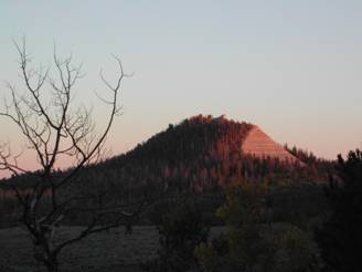
Photo caption: Sunset on the Flagstaff Formation, Wasatch Plateau, central Utah
Holocene water balance of the northeastern Great Basin (supported by NSF, 9/15/06 - 8/31/11)
In many parts of the world, water is a limiting resource for plants, animals, and humans. For arid regions such as the southwestern United states , understanding variability in the availability of water is critical to forecasting and planning for the risks associated with population growth and urban development. This understanding must include an understanding of natural levels of variability in water balance (precipitation - evaporation). The IREH group is working to generate records documenting the last ~8,000 years of water cycle history as recorded in the sediments of the Great Salt Lake . This time interval includes several well-documented warm- and cool-climate intervals, allowing us to investigate the response of the water cycle to climate change. The records, based on the isotope geochemistry of organic biomarkers, will let us probe the Holocene water cycle of this arid part of the western U.S. for prolonged intervals of dry and wet climate, and improve our understanding of when and why these intervals occurred. As a component of the project, we are also calibrating new proxies for water cycle reconstruction based on the organic fossils of brine shrimp.
Hydrological controls on nitrogen dynamics in artificially drained agricultural watersheds (supported by the Ralph W. and Grace M. Showalter Research Trust Fund, 7/1/10 6/30/11)
Subsurface (tile) drainage, consisting of buried grids of perforated pipe, may accelerate the loss of nitrogen (N) and other pollutants by altering pathways and rates of soil water and groundwater through agricultural lands. We have established a hydrological monitoring network at the Animal Science Research and Education Center to quantify the contribution soil water and groundwater to N transport in tile drainage. Physical, chemical, and isotopic data will be collected from tile drainage, precipitation, groundwater, and soil water to develop a geochemical mixing model that partitions the components of subsurface soil water and groundwater in tile drainage. A mechanistic synthesis of tile drainage will be developed that relates the relative contributions of these hydrological components to precipitation amount, antecedent hydrology, and N fertilizer applications practices. The resulting synthesis will be used to scale-up to large-scale watersheds (e.g., Wabash River) and to inform land management decisions.
Natural abundance H and O isotopes for forensic science, ecology, and hydrology.
The IREH group is continuing to work in collaboration with a number of colleagues to develop GIS-based models and tools supporting applications of environmental H and O isotope variation to a range of basic and applied science fields. This work began with our research into geostatistical models predicting the spatial distribution of these isotopes in rainwater (see www.waterisotopes.org for a description of this work). Ongoing efforts include the development of mechanistic models that can be applied over large spatial scales to predict isotope ratios in other components of the hydrological cycle and integration of data from spatial data networks with models to study hydrological processes at the catchment to continental scales. In addition to improving our understanding of water resource connectivity and stability, this research will produce products for use in reconstructing the origin of forensic samples and probing ecological systems.
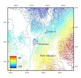
Figure caption: Modeled river water hydrogen isotope ratios in northern New Mexico (unpublished)
The Isotope Networks Portal: Data Integration for Biogeochemistry and Ecology Through Web-based Geospatial Modeling. (supported by NSF, 8/1/2008 – 7/31/2011)
A new organizational model for data-driven science is emerging and may support generation of large data sets for environmental and ecological parameters at numerous sites across the U.S. , perhaps the globe. These data will provide uniformity in measurement types and methods and public data availability, enabling unique research opportunities through providing data for simultaneous study of equivalent systems at numerous spatially distributed sites. A primary challenge facing scientific consumers of this data is that no common framework exists for accessing and integrating this data with a diverse array of other data sources and models needed to apply the data to biological research questions. The IREH group is developing a collaborative effort to produce a web-based GIS portal, INPort (Isotope Networks Portal), that will provide a transparent interface between data consumers and data sources via integrated data querying, data acquisition, and geospatial modeling operations. Users will interact with INPort through a map-based interface that will allow spatiotemporal domain and model selection and parameter specification. INPort software will conduct data identification, acquisition, and processing and model execution behind the scenes while allowing the user to monitor the project status. Model output and documentation will be provided as live, interactive GIS data layers for display and manipulation within INPort or user download. In total, INPort will provide a seamless environment for integrated data/model exploration, visualization, and hypothesis testing.